|
Was Washington Built on a Swamp? The best short answer is: No. The original site of the City of Washington, which encompasses all the lettered streets and extends from Rock Creek to the Anacostia, is best described as old farmers' fields and forests well watered with springs, two creeks and two rivers. Both the creeks and rivers experienced tidal fluctuations and seasonal flooding. In the early development of the city the draining of lowlands was not a priority. After deforestation and the cessation of farming, as the city developed the danger of inadequate drainage, especially around poorly executed building projects, became more apparent. However, the development of extensive mud flats and marshes came later in the 19th century caused primarily by the increased sediment carried by the Potomac and Anacostia Rivers due to increased settlement and farming upstream. |
 |
|
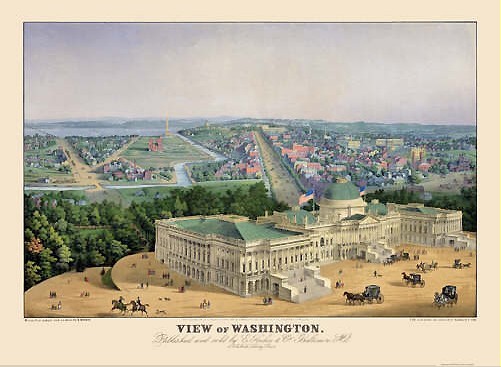
It is true that some visitors and residents of the city circa 1800 described parts of the city as a swamp, and that some memoirs of the city recalled a swamp especially along Pennsylvania Avenue. However, this was more of a characterization of parts of the city arising from the varied terrain, rather than a statement of geographical fact. A walk through the city today can still help one get a sense of the lay of the land in 1800. Apart from the obvious vantage points establishing the height of the city: the north lawn of the White House, the F Street ridge and Capitol Hill, it is important to note the rise in land south of Constitution Avenue, and to look west on G Street from its intersection with 20th Street NW. Recalling that in 1800, Tiber or Goose Creek flowed where Constitution Avenue runs, and that looking west on G Street revealed a wider Potomac River well below, you can sense that in 1800 the general impression of the city was its command of all its waterways, not any sense of inundation by them. |
|
|
|
That said, much can still be learned today about the extent of the lowlands in 1800, especially from the slope of the land between Constitution and Pennsylvania Avenues. Where that slope diminishes around 7th Street indicates the most noticeable low point of the city. Factoring in the tidal nature of Tiber Creek, one can easily picture how when the tide was out the exposed banks in that area gave the impression of being a swamp. Add to that the slow development of Pennsylvania Avenue, and one can almost agree that compared to the magnificent buildings being built on either end of the avenue, this low spot was nothing more than a swamp. Another crucial low point lies between the Mall and the foot of Capitol Hill. Tiber Creek came down to the lowland from the north, and did not completely drain Capitol Hill. The larger portion of the runoff went into James Creek which ran south to the Potomac. So on the one hand, the separation of the drainage at this low point indicates some integrity to the lowland below Capitol Hill. On the other hand, during periods of heavy rain it is hard to see how this area would not be inundated with water. In planning the city, Pierre L'Enfant never noted a swamp. But after walking over the terrain after a rain, he did notice that he was standing in water in places. His plan for the city did deal with these lowlands by calling for a canal to connect Tiber and James creeks and essentially turn those creeks into canals. However, the commercial importance of this canal was paramount and its possible role in draining the city was hardly mentioned. George Washington and many others thought commercial development of the city was a necessity and that depended on turning the mouth of the Anacostia into a deep water port. Sailing against the tides from the Anacostia to Georgetown could take several hours, so a canal to circumvent those tides was essential. Work on the canal south of the Capitol was the first project begun in the city, well before work on the Capitol and White House. However, worked soon stopped as it became apparent that the canal would take too much money too soon and that the public buildings had to be built before any commercial infrastructure. |
 |
|
This abrupt stoppage of work on the canal set a bad precedent. By 1800 the city would be pocked not only with unfinished projects but with projects that had been stopped and had already turned into blight. By creating such a large city, an extent of land equal to the size of the populated parts of London, George Washington condemned the city to many year of looking unfinished. In a sense several villages within the city were developed: next to Georgetown, around the White House, down F Street, around Capitol Hill, on the point south of the Capitol and around the Navy Yard. However, the expanse of the city made it easy for builders to abuse the land. Pits dug for clay were left uncovered; stumps in undeveloped areas were not removed; rutted farmland was left fallow; land cleared for streets and squares became overgrown with second growth tree, shrubs, and berry bushes. To the extent that the word swamp is a synonym for no development, Washington was very much a swamp. Actually, defining swamp and marsh as geographical features, the latter being reeds in shallow water bordering a river and the former being standing water in forests and fields, one would have to say that Boston, New York, Philadelphia and Baltimore are far better described as being built on a swamp than Washington. However, since those cities were planned on a much smaller scale, and were built more slowly and deliberately, they escape that imputation so commonly applied to Washington. Their swamps and marshes were transformed as the need for that land arose. Indeed, perhaps in recognition of their unique situation, In the early 1820s, after years of extolling the geographical features of the city, Washington's leaders changed their tune. Rather than explain the city's confusing development by pointing out the weakness of the planning, financing and construction of the city, they began referring to "the impenetrable marsh" which confronted the city's first developers. Soon after that, the original broad expanse of the Potomac began to be pocked with emerging mud flats many of which became marshes. Commercial shipping never flocked to the Potomac. The tidy vision of George Washington and others never came to be: a city of bustling quays, crowded canals, overseen by the palaces and forums of statesmen. Instead, the heights where contests so often stagnated into stalemate overlooked vacant shores punctuated by the few wharfs the small city needed and with what passed as the military-industrial complex of its day, the Washington Navy Yard. In a sense, the city became a swamp, but that swamp was and is entirely manmade. Then and now, natural advantages abound.-- Bob Arnebeck |